Home
Barrhead Road
What is the Balgray Connections project?
A new active travel scheme is being planned by East Renfrewshire Council to make it safer and easier to walk, cycle and wheel (using a scooter, mobility aid, or wheelchair, etc.) between Barrhead and Newton Mearns. In addition, the scheme will improve access for all ages and abilities to Dams to Darnley Country Park.
The first phase of the scheme involves realigning Aurs Road and creating a separate walking, cycling and wheeling path beside it. The central element of the path will be a new promenade overlooking Balgray Reservoir, creating a new public space within the heart of the Country Park. The designs for this first phase are nearly complete and it is hoped that the path will be completed in 2024. So this first phase is not part of this consultation.
The Balgray Connections project is the second phase of the scheme. It will connect to the first phase, making it safer and easier to walk, cycle and wheel within and between the communities of Barrhead and Newton Mearns along Aurs Road and Barrhead Road.
The Balgray Connections are at an early design stage. The proposed plans involve reallocating road space to provide infrastructure that will support walking, wheeling and cycling, as well as junction amendments, traffic calming measures, wider pavements, improved road crossings, green infrastructure and new signage.
We are now seeking views on proposed plans for Barrhead Road. We invite you to review the information found below on this page, and to then complete the short survey and leave any comments to help shape the next stage of designs for the project.
The deadline for responses is Monday 21st November 2022.
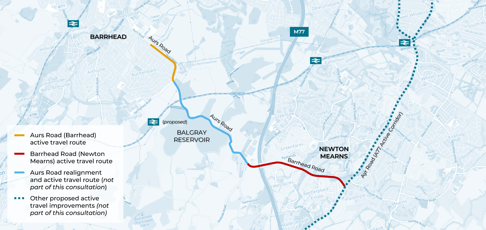
Map showing proposed new active travel route between Barrhead and Newton Mearns. Map data © OpenStreetMap contributors.
Barrhead Road Route
The Balgray Connections project will make it easier to walk, wheel and cycle between the communities of Barrhead and Newton Mearns.
The Barrhead Road route will also connect the community of Newton Mearns to a growing network of active travel improvements, green spaces, parks, schools, shops and work places, etc.
The map below shows how this section of the route will connect into the community to improve access across the area via walking, wheeling and cycling.

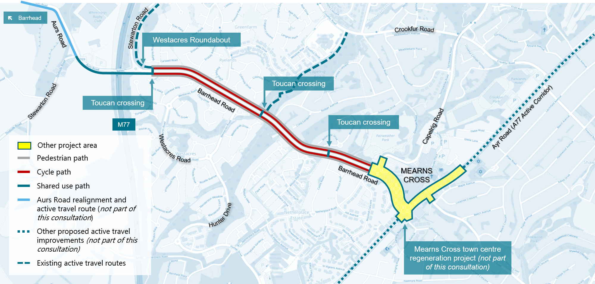
Map showing proposed Barrhead Road active travel route connections to other proposed and existing active travel routes and nearby community amenities. Map data © OpenStreetMap contributors.
The early-stage designs for Barrhead Road
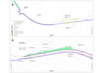
The Barrhead Road early-stage designs focus on the section between Westacres Roundabout and Capelrig Road, where segregated cycle lanes are being proposed by reallocating road space. This section connects to Aurs Roads and phase one of the overall scheme via a shared-use path for pedestrians and cyclists from Westarces Roundabout to the junction of Stewarton Road.
The designs for the Mearns Cross area will be developed alongside the town centre regeneration project, more updates on that project will be available soon.
Map showing proposed Barrhead Road active travel route. Map data © OpenStreetMap contributors.
Westacres Roundabout to Stewarton Road Shared-Use Path (Design)
The early-stage designs proposed:
- Due to space constraints across the M77 bridge and Aurs Road, a shared use pedestrian and cyclists path adjacent to the westbound Aurs Road carriageway is proposed. This will connect to phase one of the overall scheme, planned to be completed in 2024.
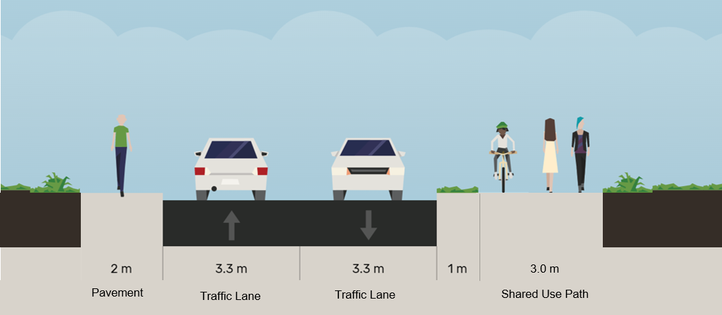
Cross section of shared use path on this route. StreetMix © Open Source.
- New toucan (pedestrian/cycle) crossing to the east of Westacres Roundabout to provide a safe connection between Stewarton Road towards Patterton Station and Barrhead Road.

Photograph of toucan (pedestrian/cycle) crossing on green for crossing.
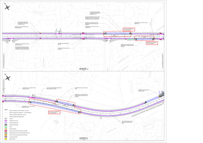
Westarces Roundabout to Capelrig Road (Design)
The early-stage designs proposed:
- New toucan (pedestrian/cycle) crossing between Greenfarm Road and Westcares Road junctions.
- Reallocation of road space to create a new 1.5m wide cycle path down both sides of Barrhead Road with 0.5m wide strips and kerb to separate the cycle path from the road.
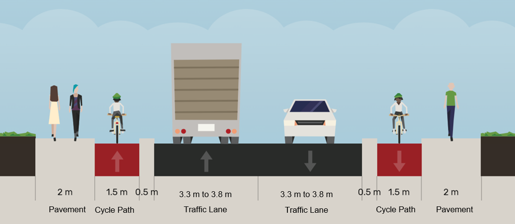
Cross section of Barrhead Road with proposed early stage designs. StreetMix © Open Source.
- Priority for people cycling across side road junctions, through use of a continuous cycle lane across junctions.
- The design options for bus stops on the route are still being developed at this time.
Barrhead Road Documents
Detailed early-stage design drawings for the Balgray Connections project on Barrhead Road can be found by following the links below. Please note that these drawings are still in draft form, and are subject to change in the months leading up to next stage of the project.
Check out the following documents
Delivery Partners
The Balgray Connections project and overall scheme to make it safer and easier to walk, cycle and wheel between Barrhead and Newton Mearns is being delivered in partnership with East Renfrewshire Council, Sustrans Scotland and Transport Scotland. The funding for this project is from Places for Everyone fund which funded by Transport Scotland.
Consultation Survey
Thank you for reading this consultation and responding to the survey. Please press the next below to complete the survey.
This engagement phase has finished

...